


 Back
Back


Regional Trails
REGIONAL TRAILS IN PRINCE WILLIAM COUNTY
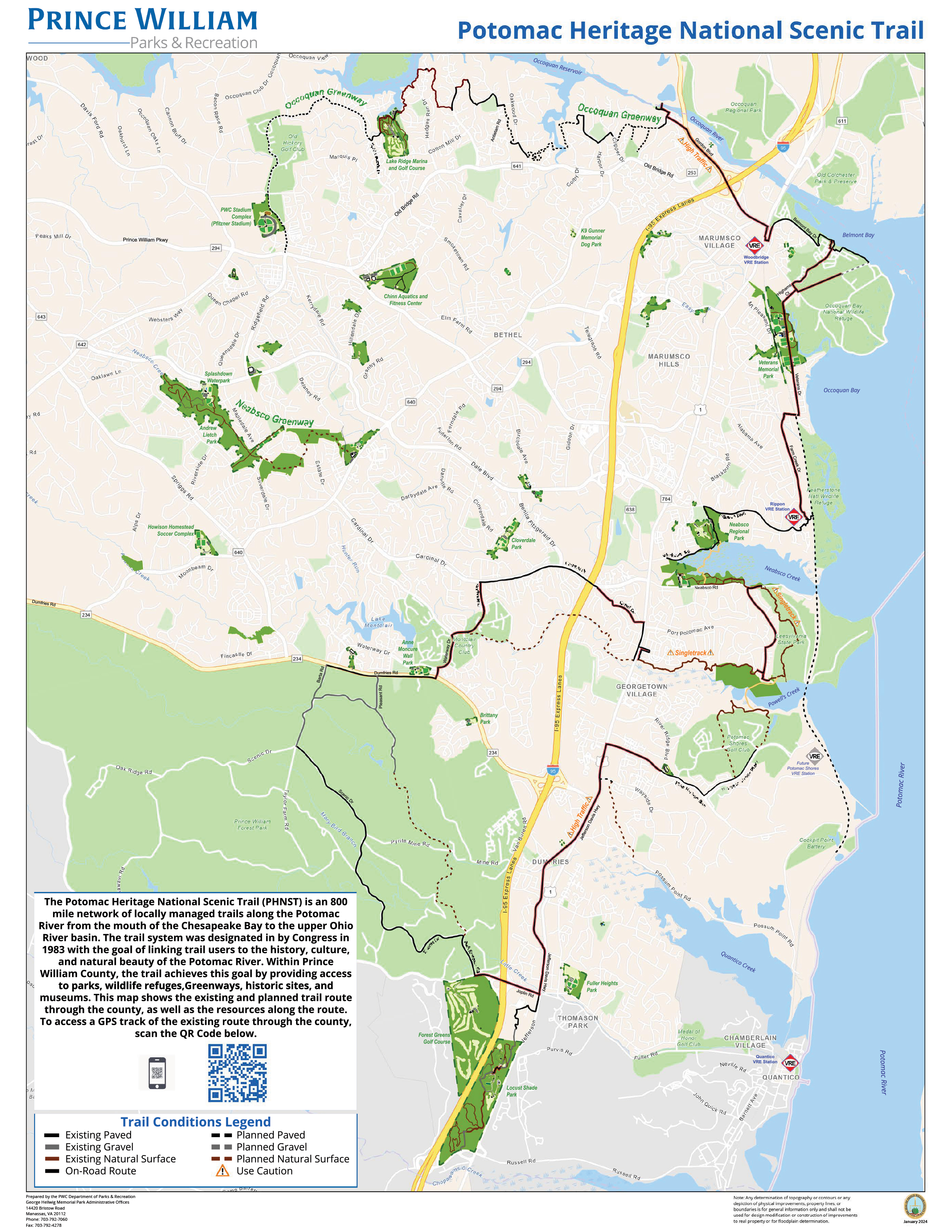
 The Potomac Heritage National Scenic Trail (PHNST) is an 800 mile network of locally managed trails along the Potomac River from the mouth of the Chesapeake Bay to the upper Ohio River basin. The trail system was designated in by Congress in 1983 with the goal of linking trail users to the history, culture, and natural beauty of the Potomac River. Within Prince William County, the trail achieves this goal by providing access to parks, wildlife refuges,Greenways, historic sites, and museums.
Within Prince William County, the trail links several parks, communities and other destinations including the historic towns of Occoquan and Dumfries, Occoquan Bay and Featherstone National Wildlife Refuges,Neabsco Regional Park, Julie Metz Wetlands, Leesylvania State Park, Prince William Forest Park and the National Museum of the Marine Corps.
PHNST in Prince William County Map | Potomac Heritage National Scenic Trail Website | Potomac Heritage Trail Network Maps

The East Coast Greenway is a walking and biking route stretching 3,000 miles from Maine to Florida connecting our nation’s most populated corridor. The East Coast Greenway is designed to transform the 15 states and 450 communities it connects through active and healthy lifestyles, sustainable transportation, community engagement, climate resilience, tourism, and more. The Greenway offers a safe place for bicyclists, walkers, runners, and more — of all ages and abilities — to commute, exercise, and visit new destinations.
Prince William County has over 20 miles of East Coast Greenway, most of which is currently on-road routing. The route follows the Rt. 1 Corridor, linking several parks, communities and other destinations including the historic towns of Occoquan and Dumfries, Occoquan Bay and Featherstone National Wildlife Refuges,Neabsco Regional Park, Prince William Forest Park and the National Museum of the Marine Corps.
 US Bicycle Route 1 was established in 1982 as an original U.S. Bicycle Route. When completed, U.S. Bike Route 1 (USBR 1) will run approximately 1,525 miles from Florida to Maine. Along with North Carolina, New Hampshire, and Maine, the portion of the route in Virginia is recognized by AASHTO.
Established in 1978 by the American Association of State Highway and Transportation Officials (AASHTO), the United States Bicycle Route System (USBRS) is a network of long-distance cycling routes in the United States that include shared roadways, on-road accommodations, and off-road shared use paths. On-road segments were selected for lower traffic volumes, posted speed limits, and generally safer riding conditions. As traffic volumes and speeds increase, conditions for biking becomes less safe. VDOT works with regional governments, localities, governments, and advocates to identify safer alternates.